|
|

|
|
|
|
If a horizon mask is not defined, it will be assumed that the link has full spherical visibility.
When defined, the horizon mask divides the visibility sphere in two sections, one with visibility, the other without.
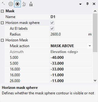
The horizon mask is defined as a semicolon separated list of [Azimuth, Elevation] pairs, in degrees. There are no constraints on the number of pairs, their ordering and their relative spacing. For example:
5.00, -40.00 ;5.00, -33.00 ;16.00, -33.00 ;16.00, -11.00 ;26.00, -11.00 ;26.00, -0.50 ;184.00, -0.50 ;184.00, -10.00 ;200.00, -10.00 ;200.00, -86.50 ;300.00, -86.50 ;300.00, -40.00
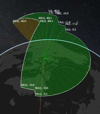
The horizon mask is referred to the satellite body fixed coordinate system, with the X coordinate pointing towards the direction flight, the Z coordinate pointing downwards to Earth, and the Y coordinate orthogonal to both. This system is fixed with the satellite body, independent of satellite attitude position and motion.
Azimuth angle is measured in the X-Y plane, clockwise from the X-axis, such that (1, 0, 0) is at 0 degrees azimuth, (0, 1, 0) at 90 degrees, (-1, 0, 0) is 180 degree and (0, -1, 0) is 270 degrees.
Elevation is measured over the X-Y plane, with positive elevation angles in the direction of Z positive (looking downward to Earth).
An additional parameter is needed to remove the ambiguity of the mask action, i.e. what section of the visibility sphere needs to be masked, whether the section ABOVE or BELOW the horizon mask.

The horizon mask can be visualized by activating the Horizon Mask Sphere in the properties pane. Azimuth and Elevation labels can also be activated, as well as the radius of the representation. The colors represent what side of the horizon mask is in visibility (GREEN) and which one is masked (RED).
Multisatellite Swath Planner - © Taitus Software Italia srl All rights reserved- info: support@taitus.it